 |
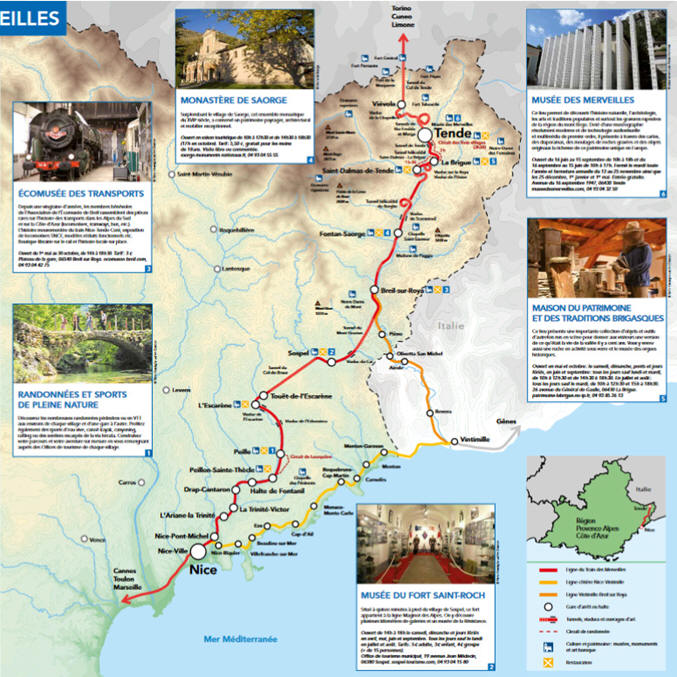
The Train des Merveilles Nice-Tende. 51 km or 32 miles, takes bout 2.5 hr each way. The train departure from Nice Thiers station at 09:00 (12€/person round trip); return departure Tende 5:22 p.m.-Nice 7:12 p.m. A day to Tende on the Train des Merveilles (the Train of Wonders, because it takes one almost to the valley where one find lots of heiroglyphs, ie the Wonders) is an opportunity to discover the back country of Nice and the Alpes Maritimes. This train’s route, a technical feat of French and Italian railway engineers, was started after the annexing of the County of Nice to France in 1860. Here and below you will find more information on the helical railway tunnel of Berghe (after the chapel: Notre Dame de Fountain) and another part of the loop track after St Dalmas de Tende. There will have many points of interest: visit the village of Tende. Visit of the Museum of Wonders. Visit of the eco-museum. There are also the strong signals of the Alps, including those of the Col de Tende above of Tende. The Roya and Bévéra valleys are also famous for their historic Italian organs and the organ festival every year with prestigious performers. HistoryThe Alpes Maritimes are steeped in history and prehistoric. At the beginning of the 19th century, the County of Nice and Savoy belonged to the kingdom of Sardinia; in 1861, during the great nationalist movements that shook all of Europe and the unification of Italy freeing itself from Austria and the Papal States, the France under Napoleon III completed the annexing of Savoy and County of Nice in exchange for supporting the constitution of the unified Kingdom of Italy under the Kingdom of Sardinia. Tende, Brig and the ridges separating France and Italy at the Col de Tende remained Italian. Franco-Italian relations were very tense at the end of the 19th century, particularly after the defeat of Napoleon III against Prussia in 1870; which is why France and Italy built many military forts for the defense of the border and any access to the valleys. Between the two wars of 1914-1918 and 1939-1945, the line of forts was reinforced by the Maginot forts. In 1940, France halted the Italian invasion (Mussolini's Italy sided with Axis forces with Nazi Germany). It was in 1947 by the Treaty of Paris that Tende and La Brigue were re-attached to France and the border was moved further north to the crest line of the Col de Tende. |
The main chronological dates are given below:
| 1388: cession of the county of Nice to Savoy. | |
| September 1792: France occupies and annexes Savoy and the county of Nice. | |
| 1815: second Treaty of Paris, the Kingdom of Piedmont-Sardinia recovers all of Savoy and annexes the Republic of Genoa. | |
| 1860: attachment of the county of Nice and Savoy to France. See map. | |
| 1861: proclamation of the Kingdom of Italy. | |
| 1870: defeat of Napoleon III against Prussia which recovers Alsace and part of Lorraine. | |
| 1873-1884: construction of the Forts Séré de Rivières, a defensive system of the borders which had taken account of the defeat of France in 1870. | |
| 1927: foundation of the fort of Rimplas, prototype of the Maginot line. | |
| 1931-1942: construction of the Italian defensive system “vallo alpino”. | |
| 1932-1940: construction of the Maginot forts in the Alps. | |
| June 1940: Battle of the Alps. | |
| June 24, 1940: signing of the armistice between France and Italy. | |
| 1947: the upper valley of Roya (municipalities of Tende and La Brigue), and the upper valleys of Tinée and Vésubie are attached to France. |
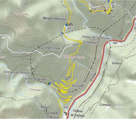
The Special HELICOIDAL Tunnels of the La Roya train route
At the end of the 19th century, with the development of the train, the question of crossing over mountain passes arose. Solutions were considered using methods based on the principle of the rack and pinion.Various systems: Apart from the rack and pinion system, there was also the FELL center rail system named after its inventor John Barraclough Fell. This system was used center rail which was gripped by special wheels and required special train locomotive. It was used in France when passing through the Mont Cenis Pass before the construction of the Mont Cenis tunnel.It was improved by Engineer Hanscotte for the Puy de Dôme railway between 1907 and 1926. There have also been other ABT (rack and pinion/third rail) systems.Cogwheel trains are said to have started appearing in 1869. They still exist in many places but also require special locomotives.The principle of helical pathwaysThe problem is, to gain altitude quickly in narrow, steep valleys.The rail track are subject to two constraints, low slope angles and curves with large radii.To gain altitude, the helix system consists of lengthening the route so as to meet these two requirements, which the helix curves allow, which are in most cases in tunnels, but rarely in the open or partially in the open.
 |
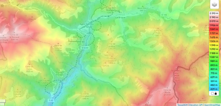
The Roya spiral tunnels Most were built when Upper Roya valley was still Italian at the beginning of the 20th century and the description is made from downstream to upstream perspective. The estimated lengths are according to French military documentation.The terminus of the train from Italy was at Saint Dalmas de Tende in 1915 and the connection of the tracks with those coming from Nice was made in 1922. |
||||||
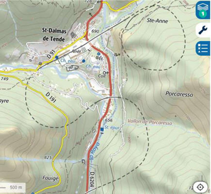 |
Berghe spiral tunnel The entrance is to the northwest on the right bank of the Roya river. It is at the outlet of the Scarasssoui viaduct at an altitude of 520 meters. After a big curve to the left and a brief passage in the open air, the exit is at the Verardo district to the northeast. The estimated length is 1185 meters and gains 90 m.Tunnels of Saint Dalmas de TendeThere are two successive tunnels:
|
||||||
 |
|||||||